
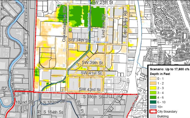
In this map, Engineers estimate a risk of between five to ten percent chance of moderate flooding in the most southern parts of Renton this winter, to the depths indicated on the map. Fortunately, many buildings in the impacted area would not be expected to see flood waters reach their floor levels (loading dock level) in this scenario. (Note that there is a five percent chance of worse flooding, and a 90 percent chance of less flooding than shown on this particular map.)
The City has posted flood maps on its website: Click here to access the maps and other useful information about flood preparation in Renton.
These maps were a lot of work to prepare, as Renton Public Works engineers had to sift through data provided by the Army Corps of Engineers and overlay it into city models to get this resolution. They also had to work through channels at the Army Corps of Engineers and Homeland Security to get the necessary permissions to publish this information. It may sound surprising that they would have to clear this release at first, but there are a variety of issues that arise in developing and publishing maps like this.
One reason engineers are cautious about publishing maps like this is that like any analysis this is only a prediction, and the reality can easily be different for any number of reasons: the storm flow split above and below the Howard Hanson dam could be different than assumed, subtle grade differences may not be accurately depicted on city maps, local flood control measures such as sandbags could affect local flows, storm and sewage system backups can change things locally, and analysis can only do so much in such a dynamic fluid-flow situation. We would not want someone to fail to plan for flooding or fail to purchase insurance just because the map shows they are likely to be in a safe area. There can always be a bigger flood than the one shown.
Another reason engineers are cautious, and the reason Homeland Security has to approve the release, is that there is a great deal of analysis that cities have performed across the US analyzing disaster scenarios; this analysis is kept private from the public to avoid advertising any vulnerabilities that exist. Homeland Security has determined that it would be disadvantageous to the public security for every engineering detail of pipeline risks, storage tank issues, water system vulnerabilities, transportation weaknesses, levee weak points, and other such information all across the country to be shared with those who might intentionally do us harm. Therefore, the information is maintained on a need to know basis. For example, there have been times when I have authorized the city to accept funds from Homeland Security to analyze risks within the city, but I am not necessarily briefed on the results unless there is an urgent risk that I have to know about.
Even with the above cautions, Renton has determined that it is helpful to share these flood maps with the public, and the Army Corps and Homeland Security have given us the okay.
Council reviewed the map data and other emergency response planning at a ninety-minute Committee of the Whole meeting last night.
There was some really useful information shared about plans for sandbags, levee work being done along the green river, the roles of various city departments in a flood emergency, the plans for shelters, and many other details. Almost all of this information is making its way onto the city website, and the meeting can still be viewed on the government access cable channel or on the city’s website.
Some new items I learned were with regard to the effort to get every business in the likely flood zone to have their own comprehensive flood response plan, complete with information about how they plan to protect their buildings (if they do), how they might move or elevate their inventory, and how and when they plan to send their employees home. Our public works director reminded us that even trying to walk through a foot or two of flood water can be life-threatening, as manholes can be opened by water pressure (and you can fall in), electric lines can short into standing water, sewage and poison can be in the floodwater, and hydraulic forces can be high enough to knock an adult down in just knee-deep water.
We also talked extensively about work to protect our potable water system, which we hope to keep active to the unflooded areas during an emergency by using isolation valves. (We would try to cut off flooded areas to prevent flood water backflow, but keep water flowing everywhere else.)
We also talked about how critical it will be to keep the metro water treatment plan active, as the 8-foot-diameter interceptor is bringing sewage from the entire eastside (all the way to Woodinville), and this sewage will quit flowing if the Metro plant loses power. Yuck!!!!
There was too much data for me to cover it all here. But please keep checking back on the city’s website, at the page linked above, to get the latest advice and information.
Recent Comments