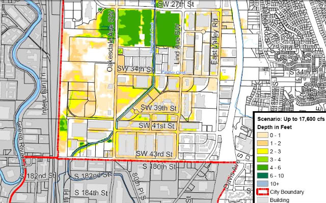
In this map, Engineers estimate a risk of between five to ten percent chance of moderate flooding in the most southern parts of Renton this winter, to the depths indicated on the map. Fortunately, many buildings in the impacted area would not be expected to see flood waters reach their floor levels (loading dock level) in this scenario. (Note that there is a five percent chance of worse flooding, and a 90 percent chance of less flooding than shown on this particular map.)
The City has posted flood maps on its website: Click here to access the maps and other useful information about flood preparation in Renton.
These maps were a lot of work to prepare, as Renton Public Works engineers had to sift through data provided by the Army Corps of Engineers and overlay it into city models to get this resolution. They also had to work through channels at the Army Corps of Engineers and Homeland Security to get the necessary permissions to publish this information. It may sound surprising that they would have to clear this release at first, but there are a variety of issues that arise in developing and publishing maps like this.
One reason engineers are cautious about publishing maps like this is that like any analysis this is only a prediction, and the reality can easily be different for any number of reasons: the storm flow split above and below the Howard Hanson dam could be different than assumed, subtle grade differences may not be accurately depicted on city maps, local flood control measures such as sandbags could affect local flows, storm and sewage system backups can change things locally, and analysis can only do so much in such a dynamic fluid-flow situation. We would not want someone to fail to plan for flooding or fail to purchase insurance just because the map shows they are likely to be in a safe area. There can always be a bigger flood than the one shown.
Another reason engineers are cautious, and the reason Homeland Security has to approve the release, is that there is a great deal of analysis that cities have performed across the US analyzing disaster scenarios; this analysis is kept private from the public to avoid advertising any vulnerabilities that exist. Homeland Security has determined that it would be disadvantageous to the public security for every engineering detail of pipeline risks, storage tank issues, water system vulnerabilities, transportation weaknesses, levee weak points, and other such information all across the country to be shared with those who might intentionally do us harm. Therefore, the information is maintained on a need to know basis. For example, there have been times when I have authorized the city to accept funds from Homeland Security to analyze risks within the city, but I am not necessarily briefed on the results unless there is an urgent risk that I have to know about.
Even with the above cautions, Renton has determined that it is helpful to share these flood maps with the public, and the Army Corps and Homeland Security have given us the okay.
Council reviewed the map data and other emergency response planning at a ninety-minute Committee of the Whole meeting last night.
There was some really useful information shared about plans for sandbags, levee work being done along the green river, the roles of various city departments in a flood emergency, the plans for shelters, and many other details. Almost all of this information is making its way onto the city website, and the meeting can still be viewed on the government access cable channel or on the city’s website.
Some new items I learned were with regard to the effort to get every business in the likely flood zone to have their own comprehensive flood response plan, complete with information about how they plan to protect their buildings (if they do), how they might move or elevate their inventory, and how and when they plan to send their employees home. Our public works director reminded us that even trying to walk through a foot or two of flood water can be life-threatening, as manholes can be opened by water pressure (and you can fall in), electric lines can short into standing water, sewage and poison can be in the floodwater, and hydraulic forces can be high enough to knock an adult down in just knee-deep water.
We also talked extensively about work to protect our potable water system, which we hope to keep active to the unflooded areas during an emergency by using isolation valves. (We would try to cut off flooded areas to prevent flood water backflow, but keep water flowing everywhere else.)
We also talked about how critical it will be to keep the metro water treatment plan active, as the 8-foot-diameter interceptor is bringing sewage from the entire eastside (all the way to Woodinville), and this sewage will quit flowing if the Metro plant loses power. Yuck!!!!
There was too much data for me to cover it all here. But please keep checking back on the city’s website, at the page linked above, to get the latest advice and information.

I lived in the vicinity of Renton back in the late 50s and the 60s.
I remember seeing flooding in the southwest corner of the map going from SW 43rd to just past Grady Way. I don’t remember any flooding in the rest of the area of the map. That is not to say that it didn’t flood, I just don’t remember it.
You’ know you’re country is s$%#$ when a central committee named “Homeland Security” gets to decide what you get to know.
I don’t remember outsourcing my risk assessment to anybody else, and I’d rather deal with a little bit of islamic terrorism than have my own government withhold flood information.
….
Kudos to the city on getting this detailed info to us… regardless of the federal goons.
“and I’d rather deal with a little bit of [thousands of people having their skin burned and charred off by jet fuel fires, smashed into the ground and steel girders at 400 MPH after a 30,000′ descent, throats cut open for clarification of evil intent] than have my own government withhold flood information.”
There, cleaned that up for you. Something tells me that when a person actually deals directly with terrorism beyond having their live feed of “The Today Show” interrupted, that person will probably think different.
You keep worrying about the Teliban breaking our sewer pipes. I’m sure it will be terrifying, but my coping mechanism is to thing about “Yakity Sax” at the same time.
Try it! It’s fun!
…
Meanwhile Iran is building a nuke, and the president that can’t even sweat-talk the IOC thinks he can just dialog Iran out of being stupid.
Yay!
The other exclusion and unknown on the maps is a levee break – then all bets are off.
Since we are downstream from Kent and Auburn, why is our risk less than them? I thought we were in for deeper waters than them.
Good question. I can’t speak about Auburn because in all honesty I didn’t pay attention to anyplace that “far away”.
Kent used to be a city smaller then Renton. The biggest reason for the change was the fact that the annual flooding along the Green River was controlled by the dam. Years after the Green quit flooding every winter you started seeing businesses popping up along HWY 167 in Kent, next came new homes. With the increase and availability of build-able land (and the lose of Farmland) came the increase in Kent.
A lot of those businesses along HWY 167 have an excellent chance of getting wet. Need an example? Think of Smith Brothers Milk Farm and the land between it and HWY 167. That is what everything else in that area may look like in a bad case scenario.
No I am not that old, I am just older then Howard Dam.
Just a random question. Why is land that is prone to flooding used for industrial/commercial purposes? This seems like a failure of zoning.
Since the dam went in, the valley has not been prone to flooding, and the lowest level land is still agricultural. Probably better than having it all residential.
Dams fail. Levees fail. Infrastructure fails. That is why I think flood prone areas shouldn’t have high capital structures on them. The risk analysis seems out of wack.
Seems like if we really wanted to plan for the loss due to weather and poor zoning, there are very few places people could live in the US. The entire southeastern coastline would have to be abandoned along with pretty much everywhere in SoCal. Plain old heat causes the most death every year.
Secrets are bad for everyone
I’m voting for Initiative 1033. I perhaps wouldn’t be if I knew there were good reasons not to do so, but the government keeps so many secrets from me that I assume the worst. The only thing I can do is cut off the flow of money, and hope the government does less of what I don’t want it doing as a result.
Perhaps with more transparency, and a little less involvement from something called “Homeland Security” which takes my tax money but ducks accountability, I would be less inclined to such drastic measures.
Re: Secrets are bad for everyone, and so is 1033
“The only thing I can do is cut off the flow of money, and hope the government does less of what I don’t want it doing as a result.”
No, that’s not the only thing you, or any other citizen, can do. Your argument proposes a false choice, false like the rest of the pro 1033 arguments.
You could take an active interest in participating in your government. Instead, you choose ballot box anarchy, intent on destroying that which you are too lazy to work to improve. You also seem to ignore the facts in that this kind of childish, simplistic approach has no history of success.
History does show, however, that if a terrorist ever did use public information to hurt our citizens, you and your I-whatever ilk would be leading the charge to point the finger at whoever you decided allowed that information to be public.
Re: Secrets are bad for everyone, and so is 1033
>>leading the charge to point the finger
Not all of us got think that way. Better to die on your feet than live on your knees etc. etc..
I live in Renton
I live on petrovitsky am I at risk for flooding
Re: I live in Renton
I’m happy to inform you that if you live on Petrovitsky east of I-167 you are not at risk from Green River flooding.