Eastrail provides beautiful vistas with level biking and walking from Renton to Woodinville


As a 20-year member of I-405 corridor transportation planning team and a founding member of the Eastrail Regional Advisory Committee, I was glad to help bring Eastrail to Renton


Our new Eastrail hiking and biking Trail on the former Burlington Northern Santa Fe Eastside Line is a wonderful new amenity in our city.  If you have not yet discovered it, you are in for a treat.  With amazing views of the lake, streams, trees and nature at a grade of less than 1%,  the trail is a delight for travelers of any degree of mobility.

The trail is a successful example of “railbanking,” where an otherwise abandoned rail corridor is preserved intact under a long-term agreement between the railroad and government agencies, allowing the corridor to become a public trail with the proviso that it could potentially be used by rail again in the future.

I was a longtime member of the I-405 Corridor Executive Steering Committee and Eastside Transportation Partnership when we learned the rail corridor would be abandoned.  Working with King County, the Port of Seattle, the DOT, and others, we protected the corridor to assure multimodal transportation options up and down the corridor.  I was a founding member of the Regional Advisory Committee for the new Rail trail, which we ultimately named Eastrail as it blended “Eastside Rail” and trail.

As someone who appreciated railroads, I was very pleased we could preserve the original trestles on the trail, and make them safe for pedestrians.

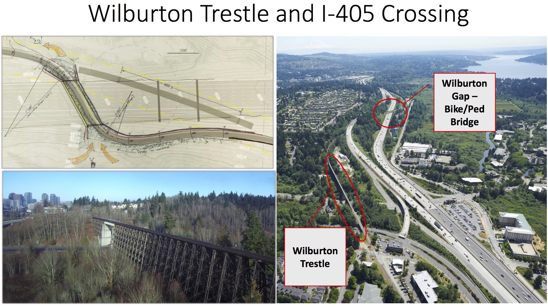
Several smaller trestles have already been converted for pedestrian use, and the plan is in work for the magnificent 1000-foot-long Wilburton Trestle in South Bellevue.  Funding issues are being worked to upgrade the trestle across I-90, and build a pedestrian/bike bridge across I-405 in the Wilburton area where the original tunnels used by the train were dismantled during the previous I-405 widening.


My wife Cathy walking the trail with me. Here it crosses over May Creek.
Trail users get this good view of the Seahawks training center


A bike and pedestrian section north of the Seahawks training center, built on the original railroad trestle.


From below the railroad origins of the bridge are obvious, and add to the trail’s charm
Details of the historic timber trestle bents and beams that carry the new concrete walking surface


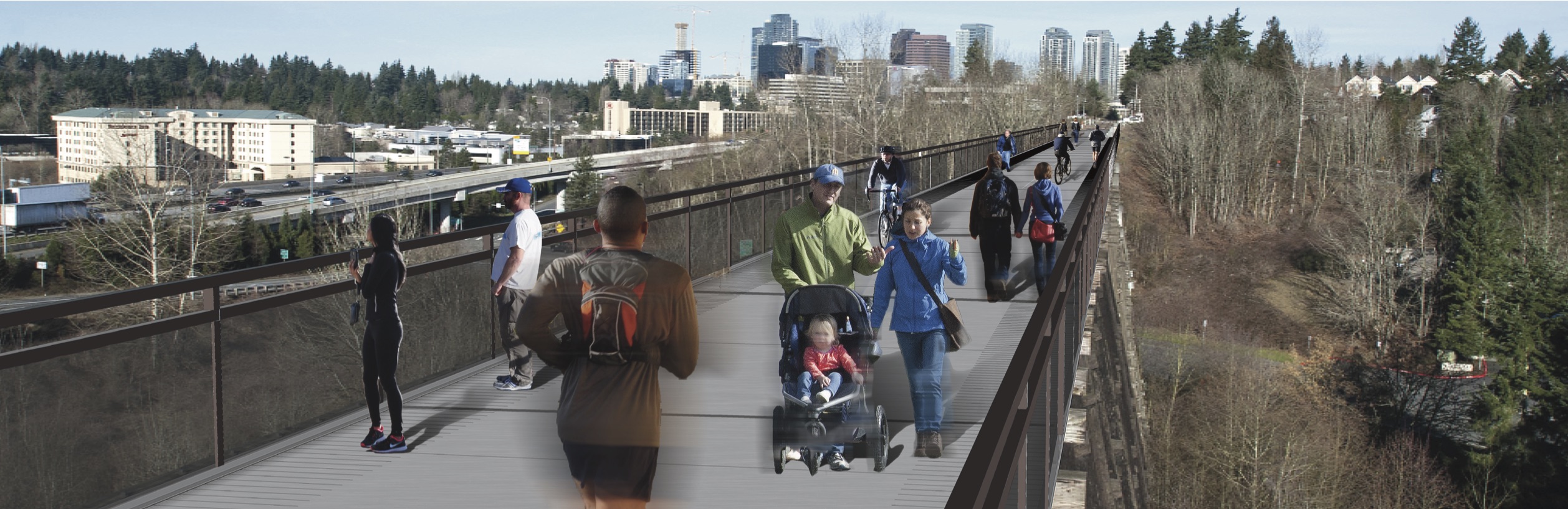
The thousand-foot-long, hundred-foot high Wilburton trestle will be converted to a bike and walking path.  Amazon is helping with funding of this portion.

Construction starting soon on incredible new bike and walking trail from Renton to Woodinville

For those of you who have not heard, Renton is partnering with King County and several Eastside cities to build a premier bike and walking trail from Coulon Park to Woodinville.  The trail will utilize the abandoned East Side Rail Corridor, that has been preserved under a Federal “rail-bank” program that keeps it intact by trail use and preserves the possibility that it could one day again have active rail on it.

The  first phases of trail construction will begin later this year, with a goal that the entire, incredible project will be completed by 2020.

This project will open the century-old Wilburton Rail Trestle to hikers and bikers, who for the first time will be allowed to traverse the 100 foot-high-wooden structure on a new deck that is 16 feet wide.  This is certain to become one of our region’s top attractions.

The above video provides a preview of the trestle crossing (minus deck and railings)

The trail will cross I-405 near the trestle, over a new pedestrian/bike bridge that will be built in South Bellevue near the location where the southbound I-405 tunnel was removed during the last I 405 widening a decade ago.  Before this widening project, the rail crossed I-405 on a lid over the freeway.

Construction in Renton will start this year with the tracks being lifted, and a new compacted gravel surface being installed in their place.  The trail will be open to the public in this form initially, and a year or two later it will be paved to 16 feet wide.  The trail is wider than most of our others, as we are trying to make room for bikes and hikers in both directions.

This trail will be a valuable connection on the eastside, and a valuable amenity for Renton residents.  Funding is coming from King County Parks  and Trails bonds with contributions from a number of other governmental agencies,

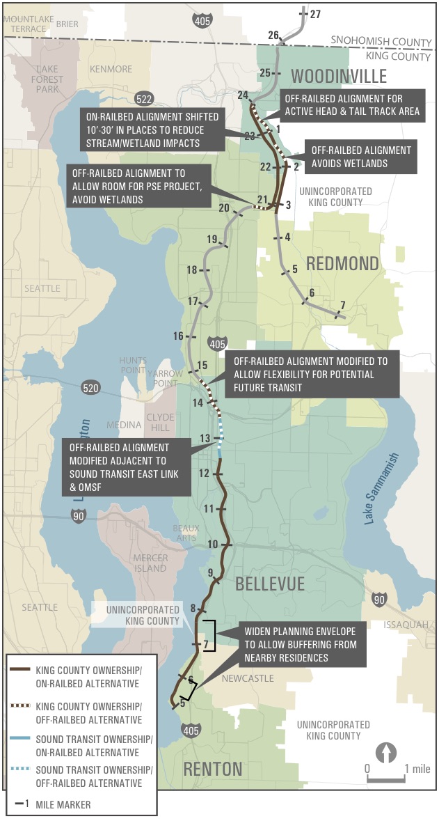
The map above shows the extent of the new trail

Beautiful Honey Creek trail in Renton Highlands

My wife Cathy and our mustang Zeus on the Honey Creek trail in Renton Highlands

On our sunny spring days, like we enjoyed last weekend, the Northwest can seem like the Garden of Eden. I only have to walk a few blocks from my house to reach a well-maintained trail that meanders along Honey Creek, through a quiet, steep valley deeply shaded by fern-covered trees. Simple old wooden bridges enable the trail to criss-cross over the creek below, keeping hikers (and bikers and horse-back riders) feeling close to the flowing water.

I’ve been enjoying these trails with my family for 26 years, and they have changed very little over the years. The City of Renton does a great job of maintaining them (in part because of utilities buried in the trails). When guests visit from out of town, if the weather is at all permitting, I take them down the Honey Creek trail. Anyone who wants to experience it can find it by parking on the street near Kennydale Memorial Hall, where Edmonds Ave. NE meets NE 27th Street. Walk eastward down the hill and enjoy the paved trail that used to be “Devils Elbow Road”. As the road crosses May Creek, at the bottom of the Elbow, walkers and bikers can access the Honey Creek trail which is finished with compacted gravel.

A maple tree adorned by ferns leans over Honey Creek in Renton Highlands

Renton City Council gives preliminary approval to proposed safety improvements on Cedar River Trail


Approximately two miles of the Cedar River trail will be getting a center stripe to separate direction-of-travel lanes, new 10 MPH speed limits, and other improvements in an effort to improve safety for all users.

At last night’s Committee of the Whole meeting, the Renton Council received a briefing from a cross-divisional “trail safety” team that the Mayor had commissioned here. The team included specialists from recreation, transportation, police, and other departments. The briefing was also attended by many citizens from the community, including relatives of the hiker who was killed by a bicycle on the trail last month, representatives of the Cascade Bicycle Club, the editor of the Renton Reporter, and other interested parties.

The council largely agreed with the recommendation of the Mayor’s trail-safety team, and gave the administration support to move forward.

There are several items proposed for the trail as well as a public awareness campaign. Here are some of the most significant items in the proposal:

The two-mile section of the Cedar River Trail, from the library to the Railroad Trestle Park on Maple Valley Highway, will receive a dashed center-stripe to separate the two directions of travel. Walkers, joggers, skaters, horseback riders, an bike riders will all be asked to walk on the right hand side of the trail except when passing slower travelers; then, they can use the left side as needed to pass, but they must be wary of on-coming traffic. The pavement is 12 feet wide in this section, so it will be divided into two six foot lanes.

That section of the trail mentioned above will be marked for a lower maximum speed. A new maximum speed limit of 10 miles per hour will replace the existing speed limit of 15 miles per hour. (While this may be disappointing to some bicyclists, I calculate that this change only adds a maximum of three minutes of travel over the entire two mile stretch for the fastest riders, and has less impact for everyone else)

Solid center striping will be added to sections where passing is considered dangerous due to visibility obstructions (just as in the case of roads). Solid stripes will also be added to direct trail users away from bollards and other obstructions in the trail.

There will be a dismount zone (where any bikes must be walked) in the lower section of the trail between the Library and the Senior Center. This is a narrower section of trail, with poor visibility at the bridges. It was judged to be too unsafe for continued bike commuting. Bikes have the option to stay on the streets above this stretch.

There will be new trail etiquette signs posted, and brochures made available at the trail, to remind users about safe practices for enjoying the trail. This will include awareness for bicyclists that they must not exceed a safe speed, regardless of the maximum speed posted. Overtaking pedestrians requires care, and groups with children or animals will require special care as they can not always be expected to reliably stay on their side of the trail.

Additional enforcement will be employed to stress the new trail rules and give warnings or citations (as appropriate) to violators. Some of the enforcement will be from volunteers, and some will be from commissioned police officers. In addition, trail users will be reminded to contact 911 if they feel anyone is obviously violating rules or is otherwise a menace on the trail.

Council members had a few suggestions, potentially including extending the lane markings and lower speed limit to the east further and investigating the feasibility of interactive speed signs that would tell riders their speed. These suggestions were taken under review by the team. Since they are additive to the staff suggestions (not in conflict), staff could probably move forward with their plan while further studying the council suggestions. We’ll get another status on this soon.

In closing, I want to emphasize that it is important to our physical and mental well-being that we all get out and move as much as we can. I have great respect for all the trail users–walkers, joggers, skaters, bikers, etc– for making it a priority to exercise. Even with the inherent risks of getting out on a multi-use trail, the collective gains to our health, longevity, and state of mind make it worth it.

A new cross-Renton bike trail, which connects to Green River and Cedar River trails, gaining support

The Renton Reporter posted an article today about the new Lake to Sound trail that is a central part of our city’s Bikes and Trails Master Plan. The Lake to Sound trail proposal is getting a lot of traction, thanks in large part to County Councilwoman Julia Patterson and County Executive Ron Sims, and the support of several south King County cities. The trail would go through five cities and two transit centers, and is largely in place except for a critical missing link in Renton.

Yesterday I participated in a press conference to share with the media about county/city plans to design and build this missing link with County Open Space money.

Here is the story from the Reporter’s Emily Garland.

Council has been working on Renton Trails and Bicycles Master Plan

City Council has recently been reviewing the Renton Trails and Bicycle Master Plan, as a start to implementing and funding a more unified system of trails for non-motorized transportation. Fr anyone who likes to ride a bike, this is a major step in improving the trail situation in our city.

Like in so many other pursuits, the funding is our next big hurdle. However, this Master Plan will make it easier for us to qualify for Federal, State, and regional non-motorized transit grants. That is, unless we have a unified plan with distinct projects, it is hard to get other agencies to send funding our way.

Our geographic situation, at the south end of the lake and the confluence of several valleys and transportations corridors improves our chances for regional funding. For instance, we have a good shot a getting a trail funded which would connect the Lake Washington trail system with the Green River trail system (to run parallel to 7th street through downtown, then near the railroad tracks, and connect near Fort Dent).

Read the report here

And the report appendices here

Bike Racks at the Landing

A bicycle commuter has been spearheading a push for additional bike racks at the Landing. It sounds like some additional racks should be going in shortly.

Here is the email chain (the oldest email is at the bottom).

Thanks to Steve Crandall, the Aerospace Manager/Bike Commuter (and old friend) that brought this to my attention. Continue reading →

Contributer Rose McMayhem– ‘Lance Armstrong’s got…well, he’s got quite a bit on me, to be honest.’

Contributed by Rose McMayhem–

Today, in what I would hesitate to call my brightest moment, I chose to ride my bicycle to work. Not just to the transit center, which is a mile away, but all the way to work, which is approximately 16 miles. Please keep in mind that the last time I attempted to get somewhere on a bicycle was 3 years ago and the ride was met with great misfortune, so not only am I woefully out of shape for such a trek, but I’m also a clumsy bike rider.

Today’s grand idea was inspired, in part, because I’m a fool who throws herself into things headfirst and then burns out quickly. Today was a great day to venture into the great two-wheeled unknown, though, since I normally do mentoring on Wednesdays, and so am not expected into work until 11- but school’s out now, so that’s an extra hour I can use on the road. I packed up my water bottle and Leatherman and headed out for a leisurely ride to work.

The following are excerpts from my mental journal along the ride.

10:01 am: This is nice. Good day for riding.

10:05 am: Why am I breathing so hard already?

10:12 am: Jeez, it’s taking forever just to get to the Lake Washington Trail.

10:15 am: So many damn hills. Who knew Seattle had so many hills? It’s like the damn San Francisco of the West.

10:17 am: Bottom hurts.

10:25 am: “Shift liberally,” the biking commuter’s guide said. “The gears are there for you to use.” Yeah, well, none of them are making this any easier. 18 gears and I hate them all.

10:28 am: The guide also said that half an hour each way burns roughly 500 calories, which amounts to losing 10 pounds over the next two months. At this rate, I’ll be lucky if I have 2% body fat by the end of the day.

10:35 am: What if I don’t make it? What if I end up like that pile of trash I just passed, decaying alongside the trail?

10:49 am: I see freeway- must be getting closer to Factoria. Wait, exit NINE? How the hell is it possible that I’m still in Renton? How did this city become so huge overnight?

10:53 am: I just saw Jesus. He appeared before me, reminded me to take my daily multivitamin, then turned into Whoopi Goldberg and vanished into thin air.

10:59 am: Hands hurt. Not sure where I am. Wish I’d brought signal flares.

11:12 am: Someone on a ten-speed just whizzed by me going uphill. F-you, ten-speed lady.

11:18 am: Pretty sure that dead bird alongside the trail just looked up at me and winked.

11:25 am: Creeping slowly up hills one foot at a time. Trying not to look farther ahead than 5 feet, lest my spirit be crushed more than it has been already by the sight of a never-ending incline.

11:33 am: Sign said the bike trail was this way, but now I’m parallel to 90 and heading East. I think I’m off course. Although I didn’t have much of a course to begin with.

11:34 am: Just passed a dude standing on the trail about two feet away from a retaining wall and staring at the wall. I know I didn’t imagine that.

11:36: Turned around. Headed in the right direction again, I think. Maybe I should call the Mister and have him come pick me up. NO! I will not accept defeat!

11:39 am: Bottom and hands hurt. And head. WHENCE ENDS MY JOURNEY?

11:42 am: Civilization ahoy! Oh Bellevue, my Eastside queen! Never before have I been so relieved to set eyes on you!

11:51 am: Dude just sped past with all his sinewy legs, lookin’ like it ain’t no thang to conquer these hills. I hate him.

11:58 am: Loaded the bike onto Route 565 at the Bellevue Transit Center and bussed it the rest of the way up to campus. Like hell I’m gonna ride the other, steeper half of the way there. Clipped a woman’s heel as we were getting on the bus and quickly apologized. She glared like I had no right to speak to her, let alone accidentally touch her. LADY, YOU DON’T KNOW WHAT I’VE JUST BEEN THROUGH. DO NOT TEST ME.

12:34 pm: Arrived at work…a little later than I’d planned, and only marginally defeated. The trip home will be radically different, I guarantee you that.