Renton police ask for your help in identifying this suspect

Commander Paul Cline 425-430-7597 October 29, 2009

Renton Police Department
Media Release

The Renton Police Department is investigating two separate Armed Robberies that occurred at “Simply Espresso” located at 401 Airport Way N in the City of Renton.

1st Incident: October 1, 2009 at 11:48 a.m. Suspect approached on foot and ordered a drink. When given his drink he implied a weapon in his pocket and demanded money from the register. After receiving the money the suspect fled on foot. The suspect was described as a W/M, early 30s, 6’0 / thin build with Brown mid-length hair. He was last seen wearing blue jeans, zip-up fleece like sweatshirt with a Puma logo, a black hat and sunglasses.

2nd Incident: October 20, 10:44 a.m. Suspect approached the Simply Espresso stand on foot, displayed a handgun and demanded all the money in the register. After receiving the money he fled on foot. The suspect was described as a W/M 30-35, 6’0 / thin build, unshaven with reddish facial hair and having collar length dark brown hair. He was wearing a green CAMO coat over a grey hoody, a black baseball cap, and dark sunglasses.

The second Robbery was captured on video and still photos from that video are attached to this Press Release.

The Renton Police Department is asking assistance in identifying the suspect in these photos. Anyone who believes they can identify the suspect or has any other information about these Robberies is asked to call 9-1-1 or the Renton Police Department at (425) 430-7500. If you see this suspect or know who this suspect is DO NOT attempt to contact him as he is considered Armed and Dangerous.

Commander Paul Cline
Patrol Operations Division
Renton Police Department

I’m sad to hear that Uptown Glassworks is at risk for going out of business

The Renton Reporter recently posted this story about Renton’s Uptown Glassworks potentially going out of business. This would be a big loss for our city, as the unique glass art studio and retail shop is a big draw to our downtown and has introduced countless new students to the world of glass blowing. It has helped anchor our downtown for nearly two decades and has become one of my favorite spots to purchase gifts for far-away friends when I want to send something made in Washington.

I hope someone with a hundred thousand dollars in upfront costs and a couple years of operating reserve can step forward to purchase this business to keep it open. Whoever buys it for $100,000 will be inheriting a large loyal customer base and a nearly twenty-year excellent reputation.


In the above photo, a delegation from our sister city of Nishiwaki Japan gets a glass-blowing demonstration (and ever participates a little) at Uptown Glassworks


Council held a 90 minute discussion about flood risk last night; risk much less than in Kent, Auburn


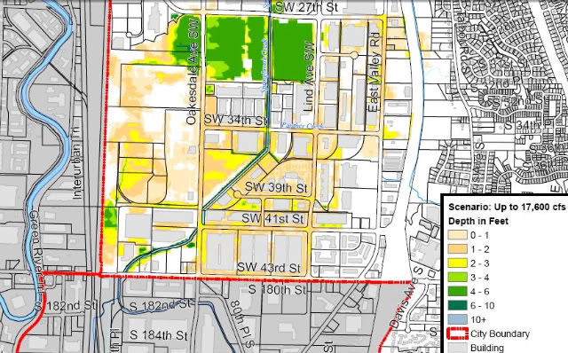
In this map, Engineers estimate a risk of between five to ten percent chance of moderate flooding in the most southern parts of Renton this winter, to the depths indicated on the map. Fortunately, many buildings in the impacted area would not be expected to see flood waters reach their floor levels (loading dock level) in this scenario. (Note that there is a five percent chance of worse flooding, and a 90 percent chance of less flooding than shown on this particular map.)

The City has posted flood maps on its website: Click here to access the maps and other useful information about flood preparation in Renton.

These maps were a lot of work to prepare, as Renton Public Works engineers had to sift through data provided by the Army Corps of Engineers and overlay it into city models to get this resolution. They also had to work through channels at the Army Corps of Engineers and Homeland Security to get the necessary permissions to publish this information. It may sound surprising that they would have to clear this release at first, but there are a variety of issues that arise in developing and publishing maps like this.

One reason engineers are cautious about publishing maps like this is that like any analysis this is only a prediction, and the reality can easily be different for any number of reasons: the storm flow split above and below the Howard Hanson dam could be different than assumed, subtle grade differences may not be accurately depicted on city maps, local flood control measures such as sandbags could affect local flows, storm and sewage system backups can change things locally, and analysis can only do so much in such a dynamic fluid-flow situation. We would not want someone to fail to plan for flooding or fail to purchase insurance just because the map shows they are likely to be in a safe area. There can always be a bigger flood than the one shown.

Another reason engineers are cautious, and the reason Homeland Security has to approve the release, is that there is a great deal of analysis that cities have performed across the US analyzing disaster scenarios; this analysis is kept private from the public to avoid advertising any vulnerabilities that exist. Homeland Security has determined that it would be disadvantageous to the public security for every engineering detail of pipeline risks, storage tank issues, water system vulnerabilities, transportation weaknesses, levee weak points, and other such information all across the country to be shared with those who might intentionally do us harm. Therefore, the information is maintained on a need to know basis. For example, there have been times when I have authorized the city to accept funds from Homeland Security to analyze risks within the city, but I am not necessarily briefed on the results unless there is an urgent risk that I have to know about.

Even with the above cautions, Renton has determined that it is helpful to share these flood maps with the public, and the Army Corps and Homeland Security have given us the okay.

Council reviewed the map data and other emergency response planning at a ninety-minute Committee of the Whole meeting last night.

There was some really useful information shared about plans for sandbags, levee work being done along the green river, the roles of various city departments in a flood emergency, the plans for shelters, and many other details. Almost all of this information is making its way onto the city website, and the meeting can still be viewed on the government access cable channel or on the city’s website.

Some new items I learned were with regard to the effort to get every business in the likely flood zone to have their own comprehensive flood response plan, complete with information about how they plan to protect their buildings (if they do), how they might move or elevate their inventory, and how and when they plan to send their employees home. Our public works director reminded us that even trying to walk through a foot or two of flood water can be life-threatening, as manholes can be opened by water pressure (and you can fall in), electric lines can short into standing water, sewage and poison can be in the floodwater, and hydraulic forces can be high enough to knock an adult down in just knee-deep water.

We also talked extensively about work to protect our potable water system, which we hope to keep active to the unflooded areas during an emergency by using isolation valves. (We would try to cut off flooded areas to prevent flood water backflow, but keep water flowing everywhere else.)

We also talked about how critical it will be to keep the metro water treatment plan active, as the 8-foot-diameter interceptor is bringing sewage from the entire eastside (all the way to Woodinville), and this sewage will quit flowing if the Metro plant loses power. Yuck!!!!

There was too much data for me to cover it all here. But please keep checking back on the city’s website, at the page linked above, to get the latest advice and information.

Question: What can be messier than having the Green River run through your living room this winter?

Question: What can be messier than having the Green River run through your living room this winter?

Answer: Having Metro’s brown river running through you living room this winter.


A manhole cover in Des Moines Iowa get’s displaced by floodwater.
Photo by Jake Bauma (some rights reserved).

With the damage to the right abutment of the Howard Hanson Dam, there has been lots of talk about homeowner’s insurance, levee improvements, sandbags, pumps, and other precautions that cities, businesses and homeowner’s might take to minimize damage if the Green River floods.

I have not seen as much focus on another key safety device that would be highly recommended for many homeowners: sewage back-flow prevention valves.


Schematic of simple sewage back-flow preventer. Image thanks to City of Fort Wayne, Indiana

If your home is on the flat-lands, surrounded by hills, it may be a good candidate for a backflow prevention valve. This would be especially true if your home is less than ten feet above the elevation of the Metro treatment plant in Southwest Renton.

This is because the sewage that leaves your home, and that leaves the homes on the hills around you, travels by gravity to the Metro treatment plant. After all, everybody knows that *ahem* “sewage” flows down hill. But if the sewage reaches still water, it will stop flowing toward the plant. And when it stops flowing toward the plant, it can turn around and start making its way toward your house.

Planners are predicting that in a worse case flood of the Green River, the Metro plant could end up being on an island, with flood waters as deep as 10 feet on some of the streets surrounding it. Unfortunately, when streets get flooded, manhole covers start admitting water into the sewer system. These covers generally deflect rain, but they are not water-tight, and when they get submerged they will not keep water out of the sewer. In fact, as the sewer gets overwhelmed by storm water, manhole covers can be completely displaced by storm water… literally lifted up by the ebb and flow of the water, and then left dislodged to admit even more water.

In some scenarios, if the streets around the Metro plant all overflowed with flood water this winter, sewage from Renton Highlands, Talbot Hill, Renton Hill, and West Hill could literally start bubbling up in the homes in the lowlands. It’s nasty, and I don’t know for sure that this would happen, but it is a distinct possibility.

Your number one…and number two :-)…defense would be a sewage back-flow preventer. This is basically just an engineered check valve, which is installed in the sewer line where it exits your home.

My son and Renton Ben are working on a website for one local company that is helping outfit homes with these valves. And I’m sure there are many other plumbers that will help you to install one if your home is at risk.

If you have a home or business in the lowlands of Renton, I strongly recommend you research this a little further and consider having one of these back-flow valves installed if you don’t already have one. A sewage backup into your home would not only be disgusting, but it would be a bio-hazard as well, and obviously leave your home uninhabitable until you got it thoroughly cleaned. Finding help getting it cleaned could be very difficult if the Green River floods, since contractors and equipment suppliers would be inundated.


The effect of sewer backup in a basement is even more dramatic. Graphic thanks to City of Regina, California