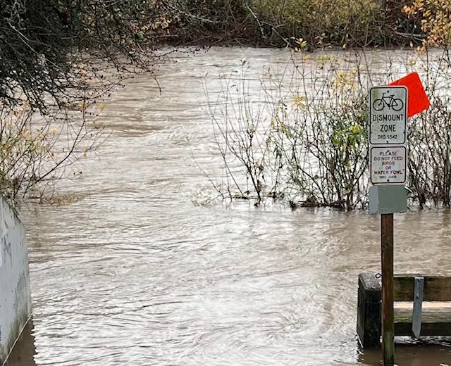
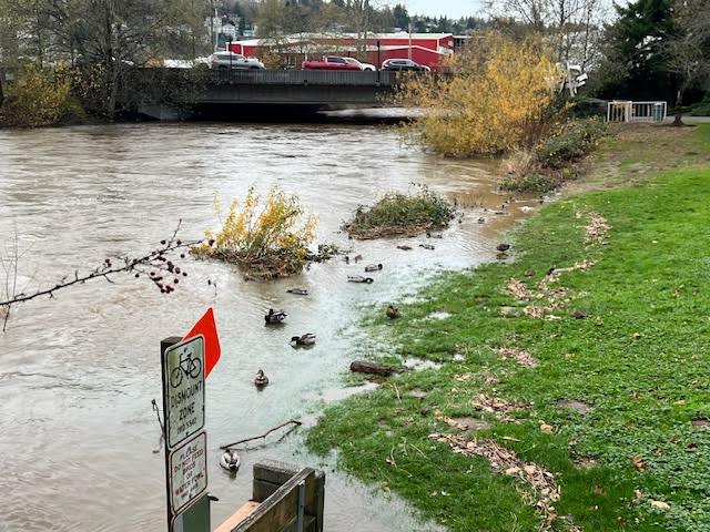
Bike Dismount Zone; the riverfront walking path near the Don Persson Senior Center is currently underwater
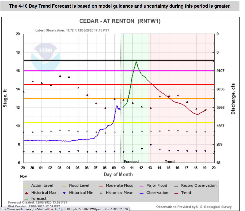
The current weather forecast shows that water could rise potentially another five feet in the Cedar River. We’re currently at 12 feet, and we could go to 17. (Note this is a forecast, subject to change.)
Looking upstream from Renton’s Don Persson Senior Center. Tomorrow and Thursday we’ll begin seeing large floating logs and debris, including whole fallen trees from last year’s bomb cyclone.
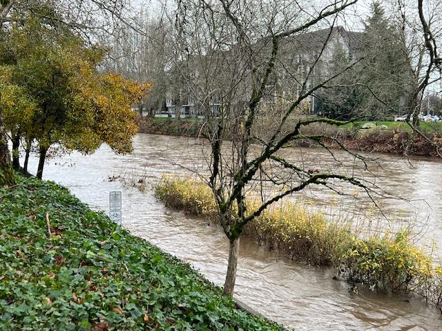
Concern Area: This is the view from this afternoon looking downstream from Renton’s Senior Center. If the river level ever rises above the bottom of this Logan Avenue Bridge, the bridge will act like a dam. Water will then accumulate behind the bridge, forming a lake, as it rises enough to overtop the bridge. The Wells Ave and Bronson Way bridges have similar situations upstream (near the library.)
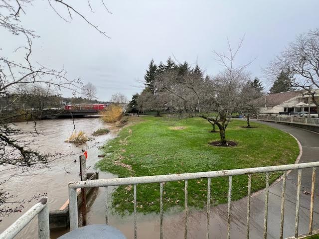
This image shows that if water ever backs up behind the Logan Street Bridge, the Senior Center could be in danger of flooding. This was one of several risks that led us to dredge the river in 1998 and 2016.

We remember that grassy hill in front of the Senior Ctr. (last picture) covered with water in a former flood. It’s going to be an interesting week. Yesterday we drove over the Cedar River and took note that the water wasn’t up to the sidewalks yet. Amazing how high it is today, Tuesday Dec. 9th, and the prediction is the Cedar River could go 5 feet higher! We’ve also been at the library when the river was very high, and under the library it was so noisy with the rushing water and woody debris hitting the posts. Sounds like a good little field trip again in the coming days!
Unfortunately, NOAA’s latest forecast predicts MAJOR flooding tomorrow in Renton. Here is their latest prediction, along with descriptions of expected impacts. If you live on low-lying property near the river, take steps to protect your property, and be sure you have a safe evacuation route. Inquire with the City of Renton or King County for locations where you can pickup sandbags and sand. Plan for the river to rise 4-5 feet higher than its current level, and potentially higher if any logjams develop.
Here’s a website that lists King County sand and sandbag distribution sites, sounds like they are fairly self service, including bringing your own shovel. https://kingcounty.gov/en/dept/dnrp/nature-recreation/environment-ecology-conservation/flood-services/be-ready/sandbag-distribution-use
12/10
I was walking along the stretch by the Senior Center yesterday and as the pictures indicate, water wasn’t yet over the planters on the lower river walk. I read that the river should reach its high today at 10 a.m. so I’ll go check it then. The dredging in 2016 has helped quite a bit in recent years, but this particular “atmospheric river” will be a test.
Unfortunately NOAA is now predicting that the river will continue to rise until about 3:00 PM tomorrow, and will crest at about three and a half feet above its current level.
We got lucky with that dredging…. The did a bit more than they needed to.
This is true. In 1998 we worked with the Army Core of Engineers and hired a contractor to dredge the river. The contractor accidentally dredged four feet deeper than planned/permitted. Renton had to do some salmon mitigation upstream as a penalty, but we didn’t have to fill in the riverbed, meaning we have extra clearance below the bridges. We dredged the lower stretch of the riverbed again in 2016, from Williams to the lake, and took it down about four more feet.
Renton should be applying for new permits to dredge since this storm demonstrated we have effectively no margin anymore, and this storm probably added new sediment to the riverbed.
13 December 2025
The great news 1/2 way through this disaster is the low body count.
Looking forward, Rentonions need to be thinking about the environmental damage done and new contamination.
Spending just a few hours watching the river over 5 days I observed tires, propane tanks and floats of trash rushing into the lake.
It’s terrible, and will take a decade to discover and clean it up before I’d feed my family fish or swim in Lake Washington. Coulon’s water is a long term mess.